|
Introduction:
It is a great honour to be here speaking to you today about the
Headwaters Project. First I would like to congratulate Surrey
Council on the leadership you have shown in addressing problems
ranging from air that is hazardous to our health to housing prices
that are beyond the reach of our average families. You were the
first city in British Columbia to require retention ponds for
stream protection, the first city to systematically adjust street
standards for reduced costs and for enhanced pedestrian and bicycle
comfort as shown in the 1997 Surrey Local Road Standards Review.
You were also the first BC municipality to propose a Small Lot
Zoning bylaw. Surrey leads the region and even Canada and North
America in these initiatives; and other communities, such as the
City of Vancouver, the City of Burnaby, and the City of Coquitlam
are following Surreys lead.
In December 1998, the City of Surrey Department of Planning and
Development agreed to enter into partnership with our research
group, a team of consultants, and a multi-constituent advisory
committee (involving various levels of government) in order to
produce a model capable of applying sustainable principles and
alternative development standards on the ground. The model that
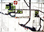
developed is the East Clayton Neighbourhood Concept Plan (Figure
2). The basis for developing this model was a set of seven principles
for creating sustainable communities that had emerged from previous
joint projects between Surrey and the James Taylor Chair. The
first of these joint efforts was the first James Taylor Chair
Design Charrette for Sustainable Urban Landscapes, held in South
Newton area of Surrey. The design brief for this was developed
using existing local and regional policy directives for sustainable
development, such as the Growth Strategies Act, the GVRD Livable
Region Strategic Plan, and other local policies guiding more concentrated
growth. Each of the charrette teams were required to accommodate
a community of approximately 10,000 (similar to the projected
population for East Clayton) in ways that provide a variety of
housing, commercial and work places, while also preserving, or
even enhancing, the sensitive stream systems that surround the
South Newton area (Figure 3).
This project led
to the 1998 Alternative Development Standards for Sustainable
Communities workshop and publication, in which the James Taylor
Chair undertook research to demonstrate the costs and benefits
of alternative development standards, with a specific focus on
green infrastructure. Among other things, this research demonstrated
that incorporating stormwater management within the rights-of-ways
of an interconnected street system could reduce infrastructure
costs. It also demonstrated how alternative developments could
result in an up to one-third reduction of infrastructure costs
for a single-family home over the same unit in a conventional
cul-de-sac development. In January 1999, Surrey City Council authorized
planning staff to explore the application of seven principles
that emerged from these projects as the basis for developing the
Neighbourhood Concept Plan for the community of East Clayton.
Together with City staff, the James Taylor Chair and Pacific Resources
(guided by the Headwaters Advisory committtee), undertook an extensive
democratic design process that produced the East Clayton Land-Use
Plan and NCP (Figure 4). The Land-use plan was approved in November,
1999, and staff have been finalizing the NCP, which, we anticipate,
will be presented to Council sometime in December. Even at this
stage, there is remarkable interest in the Plan, both from within
the region, and throughout North America.
Before speaking directly
to the Plan and the seven principles, the following provides a
brief summary of a few of the issues that precipitated this initiative.
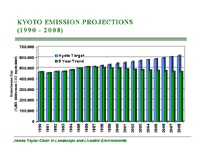
Currently, Canada
is not making its commitment under the Kyoto Convention to reduce
greenhouse gases in order to improve air and water quality (Figure
5). As a partial consequence of the way we build our communities,
people are being forced to drive more than they need to or even
want to. As the graph shows, the closer we move to the target
date, the bigger the gap becomes between the target and our actual
performance. Land-use regulations and road engineering standards
are often at fault, creating communities that separate homes from
commercial centres and schools, fragmenting natural areas, and
developing road infrastructure that favours the most efficient
movement of the automobile at the expense of pedestrian movement.
The environmental
impacts of such development include loss of fish habitat, dramatic
reductions in water and air quality, and downstream flooding of
precious agricultural lands, to name just a few. New research
from the Center for Urban Water Resources Management at the University
of Washington suggests that, when as little as 10 percent of the
watershed is covered with roads and roofs (impervious surfaces),
the fish decline. This is very bad news, because our research
shows that even low-density suburban development has 40 percent
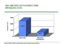
to 50 percent impervious cover (Figure 6). By reducing the amount
of pavement on road surfaces and yards, the impacts on streams
and downstream agricultural lands can be dramatically reduced.
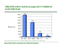
In our region, the majority of rainfall comes from very small
storms (less than 1 per storm, representing 54 percent of all
yearly rainfall). In this scenario, natural infiltration becomes
a very practical, realistic, and economic way of managing stormwater,
as the majority of water that falls can actually be absorbed into
the ground and returned to the aquifer and streams at rates that
maintain their natural function (Figure 7).
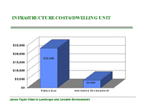
Economically, the
costs of conventional suburban development are becoming increasingly
high, both to the municipality and to the region. This includes
the alarming costs of flooding and erosion that have taken place
in past years on the agricultural lowlands due to increasing urbanization
of the uplands, and the replacement costs of infrastructure when
engineered systems fail. Our studies show that per unit cost of
alternative development (wherein for instance, streets use less
pavement, and natural drainage systems are used) can be up to
one-third cheaper than conventional development (Figure 8).
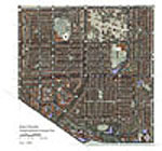
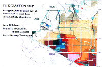
The East Clayton NCP:
The
East Clayton NCP was initiated in response to many of these issues.
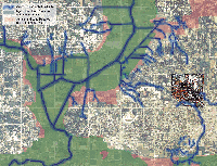
The 250-hectare East Clayton site is located on the eastern border
of Surrey. As the map shows, the site is situated upland of the
regions Agricultural Land Reserve and drains into three of the
regions most significant water bodies (the Serpentine, the Nicomekle,
and the Fraser Rivers) (Figure 9). The NCP was conceived with
this regional context in mind. This mixed-use plan supports enough
of a variety of land uses and residential/community types to maximize
affordability, sociability, and availability of commercial services
within easy walking distance for the proposed population of approximately
13,000 persons (Figure 10). East Clayton has narrow streets; roadways
throughout the site use one-third less blacktop than do status
quo suburban sites. Stormwater management, consisting of yard,
street, and larger open space infiltration devices, will eliminate
nearly all downstream consequences of development. What is particularly
unique about this project is that no other initiative either here
or elsewhere has shown how a combination of efficiencies can dramatically
decrease site infrastructure costs while also reducing dependence
on the automobile. Due to the absence of examples that remotely
comply with these policies, it was important that the seven principles
provide a model that could be applied in other areas of Surrey
and in other municipalities in the region. Thus, Surrey City Council
endorsed the principles on January 25, 1999.
The
Seven Principles:
| |
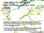
1. Increase density and conserve energy by designing
compact walkable neighbourhoods. This will encourage pedestrian
activities where basic services (e.g., schools, parks, transit,
shops, etc.) are within a five- to six-minute walk of homes
(Figure 11).
Studies show
that if it takes longer than five minutes to reach basic
services, most people will choose to drive. But in order
for a store, even a small convenience store, to be both
viable and within a five-minute walk, it needs to be surrounded
by streets containing about 10 units, or twenty-five people,
per acre. The average overall density of East Clayton will
be between 9 and 10 units per acre (over twice that of conventional
suburbs). The density also seems to be the minimum for a
viable transit system. Eventually, a rapid bus will serve
East Clayton, providing connections (at 7-8 minute intervals)
to the larger municipality and region.
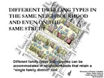
2. Provide
different dwelling types (a mix of housing types, including
a broad range of densities from single-family homes to apartment
buildings) in the same neighbourhood and even on the same
street (Figure 12).
Zoning has
been the single greatest instrument for segregating the
North American landscape according to class and income.
We realized that change could be brought about quite simply
by allowing different size parcels on the same street and
different family numbers and arrangements on each parcel.
With this in mind, the NCP provides a range of densities
and housing types. Housing will consist of low, medium,
medium-high and high density forms in detached, semi-detached,
fee simple row housing and town housing, and apartments
in the same neighbourhood and, where possible, on the same
street. A feature of most desirable neighbourhoods (Figure
13) is the tremendous degree of variety provided by houses
that address the street and that, by virtue of the size
of the lots on which they sit, and the diversity of tenure
type they provide, accommodate a mixture of family types.
Lots in East Clayton will be about one-half to one-eighth
the size of a typical suburban lot. In addition, secondary
dwelling units and suites, a feature of many of North Americas
older neighbourhoods, will be encouraged. The rental income
provided by the secondary unit will make homes affordable
while providing good housing in pleasant surroundings for
people who are beginning their careers, who dont have sufficient
equity to buy a home, or who have other places in which
they would like to invest. Thus renters have a place to
live that is far more suitable, attractive, and integrated
than is the all-too-common and ever-increasing alternative:
being segregated by income into vast and featureless garden
apartment complexes, townhouse complexes, or low-income
projects.
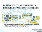
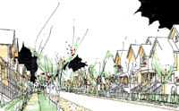
3. Communities
are designed for people; therefore, all dwellings should
present a friendly face to the street in order to promote
social interaction (Figure 14).
Adhering to
this principle means never having to see a three-car garage
eating up the whole front of a house. Blocks in East Clayton
are to be proportioned to create a fine-grained, interconnected
network of streets. This interconnected network is fundamental
in reducing traffic, congestion, and allows as many homes
as possible the opportunity to front directly onto the public
street. The Plan inherently ensures more eyes on the street,
while creating a larger backyard for private outdoor space.
Tree-lined boulevards, infiltration devices and on-street
parking will buffer the pedestrian from passing traffic.
4. Ensure
that car storage and services are handled at the rear of
dwellings (Figure 15).
Where possible,
lanes will be provided at the rear of dwelling units in
response to existing site conditions, community structure
and lot size. This will ensure building fronts are not consumed
by garages and front yards consumed by concrete, contrary
to a pedestrian street which acts to engage the resident.
Again, the lanes allow cars to gain access to units from
behind, ensuring a minimum setback and a larger private
backyard area
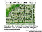
5. Provide
an interconnected street network, in a grid or modified
grid pattern, to ensure a variety of itineraries and to
disperse traffic congestion; and provide public transit
to connect East Clayton with the surrounding region (Figure
16).
Interconnected
street systems ensure that every trip may follow the shortest
possible route. Having a store within a five-minute walk
of your home is of no benefit if the five-minute walk requires
you to cut through three backyards and jump over five fences.
Yet most of our newer communities are designed to ensure
that virtually all trips are longer than they need to be.
Interconnected street systems (see Principle 4), can and
should give way to natural systems without compromising
the interconnected tissue of the local street system.
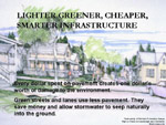
6. Provide
narrow streets shaded by rows of trees in order to save
costs and to provide a greener, friendlier environment (Figure
17).
Lighter, greener,
cheaper, smarter infrastructure is the opposite of the
heavy, grey, expensive, and stupid infrastructure we have
now. The gradual increase in the amount of pavement per
person, leading to the fact that the average suburban dweller
now has four times more pavement than does the average urban
dweller, has led to a corresponding increase in the impact,
per person, on both the environment and the public purse.
The way to save the environment, and money, is to pave less,
not more.
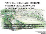
7. Preserve
the natural environment and promote natural drainage systems
(in which storm water is held on the surface and permitted
to seep naturally into the ground) (Figure 18).
If we want
to urbanize an area without destroying its streams (and
every last fish in them), then we must drain new neighbourhoods
in the same way that the original forests were drained:
through infiltration and evapo-transpiration. When rain
falls on a forest it adheres to the leaves, branches, and
trunks of trees. The precipitation that doesnt evapo-transpire
on the trees flows into the ground. Virtually none of the
water runs over the top of the forest floor to the stream.
In a mature forest, about 70 percent of all the rain that
falls on it returns to the ground. Once in the ground it
either seeps slowly into the deep aquifers far below the
surface or into the shallow water table, where it flows
horizontally to the stream bank. This process of infiltration
may take a week, or a month, or six months to enable water
to through the ground and recharge the stream.
|
If you cut off this
shallow subsurface flow, then you cut off the lifeblood of the stream
and, consequently, destroy all the fish. To protect the stream,
and the fish in it as you develop an area, you must find a way to
maintain virtually all of the infiltration naturally occurring in
the watershed. All streams are simply the manifestation of the infiltration
performance of the soils in its watershed. So a city, as it builds,
must respect these soils and their streams by allowing them to continue
to perform together in the way they always have. Green systems are
an essential part of the East Clayton Plan. The initial 4-day charrette
process -- held in the spring of 1999 and used as a means of gathering
all interested parties around the same table to establish a shared
vision of the site -- resulted in a land-use plan that used existing
ecological systems as the plans basic armature.(Figure 19). Streets,
neighbourhoods, and land uses were structured around this green
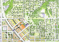
framework. The Larger Picture: It bears discussing how the East
Clayton plan fits within the process of planning for the larger
Clayton Area. In 1998 Surrey Council adopted the Clayton General
Land-use Plan. As Figure 20 shows, the plan for East Clayton was
conceived with the entire Clayton area in mind; East Clayton would
be the most concentrated portion of this approximately 800 acre
area. The primary commercial area is located so as to create a true
centre for the Clayton community at the corner of 72nd Street
and 188th Street. This area is envisioned as a Main Street area,
with street-oriented commercial, store-front offices and services,
and parking on the street (as opposed to on large paved parking
lots). Housing is also proposed above commercial locations so that
the area will remain lively and populated. At a finer grain, neighbourhood
commercial locations are proposed throughout the community as a
way of providing local, every-day services for residents within
a five-minute walk of their homes. A total of five neighbourhood
commercial locations a proposed throughout the community. These
locations are considered essential to providing easily accessible
and walkable services for local residents; they are also key to
achieving significant reductions in automobile use.
Conclusion:
In closing, it is important to re-emphasize that the East Clayton
NCP doesnt exist in isolation; rather, its success is dependant
upon a coordinated and consistent approach to planning in adjacent
areas. One of most unique elements of the plan is the level of integration
that exists among the elements; eliminating one or two of the elements
results in a plan that is far less than the sum of its remaining
parts. Your original authorization to your Planning Department in
1999 was to explore the application of the seven principles to
East Clayton. This they have done, and done well. So if this Council,
in full recognition of both the opportunities and challenges that
lie before you, cannot support this sustainable approach, then the
exploration you authorized will have produced a useful result. You
will have discovered that the political and social costs of sustainable
development are too high for your city to pay. But we have every
reason to expect this Council to continue to lead the region. If
we had doubts we would not have worked with you for so long. Since
1995, UBC and its partners have provided nearly 10 person years
of effort for your various sustainability initiatives, all at no
cost to the City. We have been honoured to participate. As long
as your commitment to sustainable development remains as strong
as ours, we see no reason to stop. In our view, the East Clayton
project is the most advanced undertaking of its kind in North America,
and offers hope that we can create more affordable, livable, and
sustainable new communities.
|