for Sustainable Communities
patterns applied
|
THE
WAY IT'S HEADING The second map depicts how the study area may look thirty years from now. For this plan it is assumed that the land parcel will be developed in rough conformity with the planning, engineering, and subdivision regulations that have held sway in the past. The urbanised area (pink) has expanded to cover most of the land and the pattern of the landscape has been primarily determined by the needs of the automobile. The areas within the old quarter-mile sections have been filled in with residential cul-de-sacs. With no additional traffic-carrying capacity built into the interiors of these quarter-mile sections the surrounding arterials become overloaded, and many of them must be substantially widened. Most neighbourhoods lack easily accessible commercial centres and as a result most residents must use autos to satisfy all commercial needs. This being the case, the location and layout of shopping centres is determined by their accessibility to motor vehicles rather than by ease of access by foot or by transit. . Virtually all of the pre-existing streams and associated nature habitats have been erased from the landscape; rainwater now flows only through pipes and valuable community linkages have been lost. Parks and playgrounds, while numerous, are widely separated, and there are no connections between these green spaces. The only corridors available for pedestrians and bikes are the arterial roadways where biking and walking are |
Click
map region to view detail
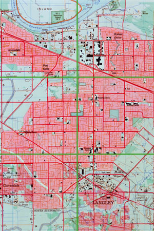 both unpleasant and unsafe. In addition, the provision of an expensive subsurface drainage, and a separate recreation system means higher costs and a less efficient system. Finally, due to a plethora of cul-de-sacs and an overly complex street pattern, the district cannot be efficiently served by transit. Even though the district has been completely developed, the average density is a relatively low 4.0 units per acre. This inefficiency is the result of unnecessarily wide residential streets, restrictions on auxiliary units, residential lots that are virtually all larger than 6,000 square feet, and large requisite building set-backs which demand that buildings be placed far from the edge of the street. |
|
|
|
|
|
|