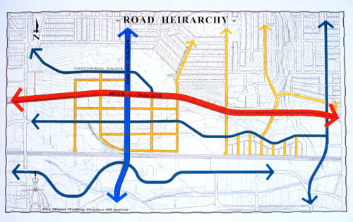
Example
1
In
Team Twos proposal, the grid pattern integrated into the
existing subdivision structure of the Brentwood site. Assuming
that eighty metres is the average distance covered in one
minute of walking, and given block sizes of 300-by-600 feet,
it would take no longer than approximately ten to twelve minutes
to walk from anywhere within the grid to either school, work,
transit, or commercial services and recreational amenities.
Example
2
As
Team Fours Land Use Plan shows, the historical street pattern
of the Brentwood District is maintained, but with smaller
block units so as to achieve a similar pedestrian scale of
development. To the south, smaller block sizes are integrated
with larger parcels, encouraging a mix of development types
and densities. Medium-density row houses are proposed for
the southwestern portion of the site, while higher density
forms, such as courtyard housing, are proposed for smaller
block units in the northeastern portions.
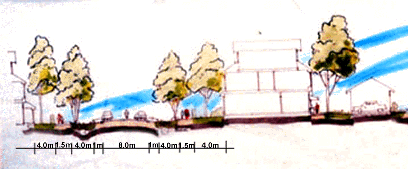
Example
3
A
section showing narrow residential streets. Narrow streets
save more land and have slower traffic than do wide streets;
they are cheaper, have fewer ecological impacts, and can be
more easily shaded with street trees. In this example, 1 metre
wide gravel shoulders collect water runoff, which is then
collected by roadside swales composed of peat and gravel.
Variations of this kind of street profile are common in many
of Vancouvers older neighbourhoods.
|
|