|
Demographers and planners suggest that changes in the regions population will have significant implications for the amount and type of housing needed. Over the next twenty-five years the population of the metropolitan Vancouver region is projected to increase by 58 percent, from a 1996 population of 2,098,900 to a 2021 population of 3,311,500.1 This implies an average annual population increase of 1.8 percent. Accompanying population growth will be shifts in age structure and household size. By the year 2021 over half the population will be in the over-forty-five age group and household size will be smaller, meaning an overall increase in the number of households. The goal of local and regional policy is to provide housing at higher densities while still allowing families to live in dwelling units that have direct access to the public realm (i.e., ground-oriented housing). In fact, the GVRD has concluded that over the next fifteen years, about 70 percent of the additional dwelling units needed to accommodate increased growth in the region will be ground-oriented.2 |
|
| No longer just associated with the single-family detached home, ground-oriented housing includes forms such as the duplex, fourplex, townhouse, and row house. In its medium-density form, ground-oriented housing is distinguished by having individual unit access at-grade, in contrast to other types of medium-density housing (i.e., garden apartments or condominium units) that, more commonly, have unit access via a central entrance and/or interior hallway. Occurring at densities ranging from approximately ten dwelling units per acre to thirty-five dwelling units per acre, medium-density forms are gaining a larger share of the market and represent as much as 25 percent of all ground-oriented units.3 | |
| The most common high-density ground-oriented form
in our region, the typical townhouse development, features strata-titled
ownership 4 and, most often, has units
facing inward, towards car access and parking. Virtually unknown in
our region is an earlier form, the free-hold townhouse. In this
type, units open directly onto the street and parking usually occurs
in a rear lane. It is important to emphasize that this pattern, so
common in most of North Americas older cities, uses land efficiently,
allows outright home ownership, and eliminates the ambiguous semi-public
space typical of most new suburban townhouse developments.
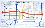
Ground-oriented housing offers many of the benefits associated with the single-family detached house privacy, security, freedom of ownership in a higher density form. However, many have questioned the capacity of the strata development form to foster a sense of community and to reduce auto dependency. It has also been suggested that the preponderance of this type of housing does not reflect market preference but is, rather, the product of the present regulatory environment, which through zoning by-laws and traffic engineering standards (such as limiting the number of curb-cuts allowed into a development parcel and setting minimum parking requirements) produces auto-focused rather than people-focused communities. We asked the design teams to provide suggestions for how this form of housing could be improved. As discussed in the introduction, design charrettes are an ideal vehicle for resolving the conflict between contradictory policy goals relating to landuse. For instance, increasing density may make public transit a more viable option, reduce car use, and potentially improve the street environment for pedestrians and cyclists. However, this increased density may also have a negative effect on water quality. A challenge faced by charrette participants was how to increase choices in the marketplace for ground-oriented housing while still meeting other sustainability goals. The solutions provided were simple and compelling, and they point towards the need to reconsider our unsustainable regulatory practices. The charrette proposals discussed below all conform to the Brentwood Town Centre Development Plan, which calls for the accommodation of 9,300 residential units on approximately 200 acres, resulting in a residential density of about thirty-two units per acre on average. These units would be supplied in an expanded range of housing choices, including medium- and high-density multi-unit developments and medium-density ground-oriented units. Approximately half of these units would be high density, and half would be medium density. No zones allowing single-family detached housing are proposed, although the surrounding area is dominated by this type.5 This local area plan provided charrette designers with a basic planning framework for the site; however, it left many important urban design and community design questions unanswered. For example, in what proportion, and in what form, should high- and medium-density housing be allocated in order to achieve the best results? The charrette proposals responded to such questions by incorporating housing and community uses within a tightly woven grid of streets, pathways, and open-space links, resulting in more sociable and ecologically sensitive communities. The existing pattern of development on the site has been influenced by its early subdivision into an enlarged gridiron pattern (Figure 1). This enlarged grid has led to a development pattern in which individual parcels are often larger than the standard 300-by-600 foot block size apparent in the surrounding districts to the northeast and west. Redevelopment, if present trends hold, will most likely occur on a parcel by parcel basis. These block sizes are too large to allow high-density ground-oriented development in such a way that would enable all dwellings to front onto a public street. Much thinner block sizes are required. The City of New York, for example, achieves its high densities while still adhering to the ground-oriented townhouse pattern by having very thin blocks (close to 200 feet wide). There are only two possible outcomes for the Brentwood site, given its large block size: either the City of Burnaby requires developers to break down development parcels into smaller block sizes and cede certain streets to municipal responsibility, or Burnaby accepts the emergence of gated communities (which would be the inevitable outcome of developing these super block parcels as-is). It is important to distinguish between the nature of public and
private streets, as they each give rise to a different set of physical
circumstances. New medium-density developments typically rely on
a network of internal (essentially private) streets for circulation.
It is speculated that this is partly due to reluctance on the part
of municipalities to assume additional responsibility for public
street infrastructure and maintenance, and partly due to concern
for reducing conflict while maximizing traffic efficiency on arterials.
Even where developers are permitted to include public street dedications
as part of a development, existing policies that restrict access
onto arterials typically take precedence. The inevitable consequence
of this is the creation of large super block units surrounded
by arterial streets. The location and access of on-street parking
is also an important factor. The absence of parking on many public
streets means that residents and their visitors must always access
units from an interior roadway system. This affects the way that
the fronts of units function and, ultimately, the way in which the
street functions as a public place. These problems are addressed
in the examples below, where the sites existing block pattern is
broken down into smaller units. |
|
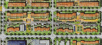
| Charrette Solutions In Example 1, the sites existing coarse street pattern is replaced with the finer-grained, 300-by-600 foot grid, resulting in smaller, more regular block sizes and creating a more interwoven network of streets (see Example 1 and 2). By using more rather than fewer streets, all ground-oriented dwellings can exit onto a public street, thereby clarifying the relationship between public space and private space and enriching community life. In another scenario, proposed by Team Four (Example 2), more streets have been added and block sizes have been reduced in order to promote diversity, flexibility, better circulation, and greater numbers of people on the street. Team Four also proposed to narrow the streets to make them richer places for pedestrians and bikes while forcing traffic to slow down (Exalmple 3). The fine grain interconnected street pattern guarantees that each trip to the store or to the bus is via the shortest possible route, thus reducing the necessity to resort to a car for even ones most basic needs. |
|
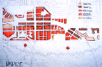
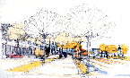
| Example 4 and 5, from Team Ones plan, shows how the finer-grain grid, as a living, working component of the neighbourhood, provides opportunities for allotment gardens, composting, and rainwater storage. Each of the working greens is connected, at mid-block, to the larger neighbourhood system by a series of green links. These links connect (northward) to commercial and transit nodes along Lougheed Highway and Willingdon Avenue and (southward) to the Still Creek basin. Within the higher-density residential core, the central green becomes an urban open space (see Example 6). | |
| Priority for vehicles is lessened in a village street
pattern, in which buildings are closely spaced and front directly
onto streets and sidewalks. Using this pattern, residential areas
can be intensified by allowing zero lot lines and by using party walls
on fee simple parcels as narrow as twenty feet (see Examples 7 and
8). This type of development supports a mix of incomes and household
sizes. A 2.5-storey unit on a parcel as narrow as twenty feet could
accommodate up to 1,500 square feet of interior space, with additional
floor space available in the attic floor above and in the full basement
below. Basement suites can be included and may have their own private
access to the public sidewalk.
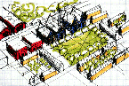
In many of the Team proposals, occasional residential towers, with at-grade commercial uses, provide continuous streetfronts along the core streets; and more medium-density forms (such as stacked townhouses and row houses) provide the necessary transition between the high-amenity core and low-density fringes. Built at a scale of 3.5 to 4-storeys, all units front onto (and are accessed from) the street. A type of stacked courtyard housing, similar to that found in many European cities, is suggested as an appropriate interface between the high-amenity urban core and the surrounding lower-density neighbourhoods. In this type of housing, the interior of the block becomes a common lane space, providing residents with semi-private open space (Example 9). Conclusion This exploration of charrette designs has demonstrated the economy, equity, and ecological integrity of a fundamentally different approach to sustainable urban design. Underpinninng this approach are several basic principles for building viable communities. These include: the integration of various housing types and tenures; ground-orientation of units where possible; a mix of uses; and walkable connections to neighbourhood destinations. While this approach is different, it nonetheless has many precedents. This traditional urban form, updated for enhanced efficiency and ecological performance, is a proven neighbourhood pattern that is worthy of rediscovery. |
|
| Notes
1 David Baxter, Homes in Metropolitan Vancouvers future: Housing Demand by Structure Type, 1996 to 2021 (Vancouver, BC: Urban Futures Institute, 1998). 2 Greater Vancouver Regional District, The Livable Region Strategic Plan: Managing Greater Vancouvers Growth (Vancouver, BC: Greater Vancouver Regional District, 1993), 17. 3 Ibid., 11; Greater Vancouver Regional District - Housing Task Group and Strategic Planning, Examples of Ground-Oriented, Medium-Density Housing Projects in Vancouver (Vancouver, BC: Greater Vancouver Regional District, 1996), 1. 4 Strata-titled ownership, typically seen in attached-unit housing, restricts the outright ownership of an attached dwelling to the built structure of the unit. The land under and around the unit is owned collectively. 5 City of Burnaby, Brentwood Town Centre Development Plan (Burnaby, BC: City of Burnaby Planning and Building Department, 1996), 14. |
|
|
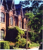
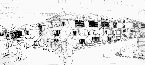
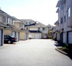 A typical auto-focused development
|
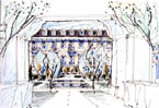
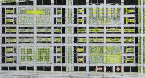 Example 5
|