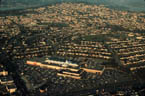
INFRASTRUCTURE
| A fundamental question explored by charrette participants was how
to improve the sustainability of the charrette site through taking
an integrative and ecological approach to stormwater management. Traditional
approaches to stormwater management focus on conveyance, where stormwater
runoff is collected and concentrated through a network of impervious
gutters, drainage structures, and underground pipes. In contrast,
alternative stormwater systems often focus on infiltration and treat
stormwater as part of the hydrologic cycle, thereby enhancing aquatic
and terrestrial habitats.2 With alternative
stormwater management, natural processes are incorporated into a larger
urban open-space structure as Best Management Practices (BMPs), chosen
for their specific function and suitability to a particular site.3
Open-space networks provide habitat for urban wildlife, offer recreational and alternative transportation opportunities for communities and facilitate stormwater infiltration.4 Research has shown that these open-space networks can provide a natural alternative to the traditional infrastructure system of impervious gutters, underground pipes, storm sewers, and treatment plants (which discharge into local streams through sewer outflows with or without treatment).5 We refer to these networks as ecological infrastructure. Watersheds are the most appropriate unit for ecosystem-based planning as they can be clearly defined at a number of geographic levels (from a basin at the regional level; to a sub-basin at the municipal level; and to the urban stream at the individual site or community level). The quality of an urban stream depends on the interaction of many different physical and biological processes, and each is influenced by the degree of urbanization present in the surrounding watershed. Urbanization generally leads to an increase in impervious cover in a watershed, impacting the morphology, water quality, and biodiverstiy of urban streams.6 Typically designed and planned by public works officials and engineers for efficiency and economy (and to protect public health, safety, and welfare), the potential ecological and amenity impacts of traditional residential stormwater management have been largely ignored.7 A challenge facing local municipalities is to preserve riparian corridors and to promote sustainable design by requiring alternative stormwater management techniques and ecological watershed planning in order to protect local streams. Charrette teams were required to confront this challenge. Each team suggested a number of alternative approaches to traditional stormwater management by incorporating concepts of ecological infrastructure into their schemes, specifically through the use of BMPs. One easily quantifiable environmental indicator of the health of urban watersheds is the degree of imperviousness in any given urban development.8 Substantial research indicates a consistent correlation between the amount of impervious surface in an urban watershed and the health of its riparian habitat. Impervious surfaces can be defined as anything that prevents the infiltration of water into the soil: this includes rooftops, roads, driveways, patios, parking lots and sidewalks as well as bedrock outcrops and compacted soil. The urban runoff coefficient (or the fraction of rainfall that is converted into storm runoff volume) closely tracks the percentage of a watersheds impervious cover.9 Large areas of impervious cover mean an increase in runoff volumes and velocities and a corresponding decrease in infiltration, each of which translates into greater erosion rates, higher floodplain elevations, lower rates of groundwater recharge, and lower water tables.10 Impervious surfaces collect and accumulate pollutants from the atmosphere, vehicles, construction, and various urban activities. Because it flows off the land from a variety of sources, and not from municipal stormwater infrastructure, such runoff called non-point source pollution is largely unregulated and is now considered one of the leading threats to water quality. Indeed, the primary threat to water quality in the Still Creek catchment area is from non-point source pollution via stormwater runoff. Rainfall, snowmelt, and irrigation carry the contaminated residues of human use including nutrients, metals, hydrocarbons, phosphorus, bacteria, fertilizer, and pesticides and, following gravity, transport these pollutants to the nearest water body, which in this case is Still Creek. The more impervious surface an area has, the more abundantly and rapidly contaminants are discharged into sensitive aquatic systems. The amount of imperviousness in an urban area varies according
to different land uses. Commercial strip development has the highest
rate, at around 95 percent coverage, with industrial development
not far behind.11 On average, 54
percent of the typical suburban detached single-family home lot
is covered by impervious material. House, storage, and garage structures
typically cover 29 percent of the site, and an average of 25 percent
is paved for sidewalk, driveways and roads.12
Different types of impervious surfaces also transmit runoff at different
rates. For example, roofs and patios generally produce less impact
because they often drain to a lawn or other permeable area, as opposed
to roadways, which typically channel runoff directly and swiftly
into a subsurface storm-drainage system. |
| Various attempts have been made to measure the threshold values
at which stream degradation first occurs. It has been suggested that
when impervious cover in a watershed is less than 10 percent local
streams are still protected. Other studies show that urban streams
surrounded by 10 to 30 percent impervious cover are impacted, and
impervious cover greater than 30 percent results in severe stream
degradation.13 At this level, aquatic
insect populations an important food source for fish decline,
and sensitive species are replaced by species more tolerant to stress.14
Table 1 provides a summary of the impacts on urban streams that suffer
from increased imperviousness in the watershed.15
If we understand the watershed context of each development site, then stormwater can be managed in situ, as opposed to being transported underground to the nearest body of water. Small and simple natural collection and treatment strategies located at the point where runoff initially meets the ground, repeated consistently over an entire project, will usually lead to the greatest water quality improvements for the least cost. The further the water is conveyed, the more expensive the system and maintenance requirements. Several sources suggest that alternative stormwater management can achieve the following objectives 16:
The development of stormwater policy in Canada has been slowly
evolving. Throughout the nation, municipalities are able to encourage
alternative stormwater management through official community plans,
reviews, and approvals of development plans, as well as through
by-laws.17 The Official Community
Plan for Burnaby sets out broad directions and policies to guide
the citys development over the next decade, integrating land use,
transportation, the environment, heritage, community facilities
and services, and social and economic planning into one broad strategy.18
In October 1996, Burnaby City Council approved the concept of using
an integrated stormwater management approach to watershed management
issues. This approach included incorporating surface stormwater
techniques for managing competing environmental, technical and
development values in the watershed.19
Other Burnaby initiatives that support the use of ecological infrastructure
include: the Urban Trail Program; the State of the Environment Report
for Burnaby (SOER)20; the establishment
of design guidelines for Environmentally Sensitive Areas (ESAs)21;
the Parks and Recreation Master Plan (City of Burnaby 1998); the
Local Improvement Program; and a variety of land-use management
tools (such as landswapping and density bonus incentives, comprehensive
development zones that enable more flexible and responsive design,
and ongoing public acquisition of all significant stream corridors). |
| Infrastructure components (including roads, storm drainage and water/sewer
service) make up an increasingly prohibitive cost. Reducing imperviousness
on a development site results in a reduced need for storm drainage
which, in turn, results in significant cost reductions.22
By promoting alternative stormwater management techniques that take
advantage of natural materials and processes, costs can be further
reduced.23 Table 2 shows a cost comparison
between a conventional subdivision and a residential development and
indicates significant savings on a cost per unit basis when
ecological infrastructure is used.24
Yet despite all the evidence, municipalities often report that there are inadequate finances for infrastructure redevelopment as well as inadequate user density to rationalize the cost of changing older systems. Elected officials are often reluctant to fund stormwater management development because infrastructure problems affect only a relatively small percentage of taxpayers.25 In addition, complex institutional arrangements involving several agencies often impede the implementation of alternative stormwater systems in urban areas. In most municipalities, there is a complex approval process for storm drainage plans often involving engineering departments and provincial environment agencies and local governments may be concerned about legal liability because of their overall in-experience with alternative designs.26 Socially, ecological infrastructure enhances a communitys topographic diversity and recreational opportunities. It connects people to nature by providing evidence of belonging to a larger natural cycle. In addition, wetland vegetation, grassed swales, and increases in green space enhance air quality and can often improve the visual aesthetics of community.27 Ecological infrastructure in urban areas implies a more naturalized, or wild, landscape aesthetic. While considered by many to be an asset to a development, in terms of visual, recreational, and even financial value, such an aesthetic is often resisted by the public, planners, developers, and public works officials.28 A recent study concluded that in order to implement storm-water management, a transition period is required to enable municipalities to develop and streamline guidelines, and to enable developers and local residents to become familiar with them.29 By using vegetation as a structural element, ecological infrastructure assists in improving the microclimate of developed areas. Effects such as increased shading, wind protection, cooling through evaporation, and noise abatement provide better habitat for both human residents and wildlife. The proper selection of plant materials for an open drainage system can improve the infiltration potential of landscaped areas. When combined with effective planting design, open drainage can provide natural nesting and foraging areas for wildlife that, normally, would be displaced by development. The energy embodied in conventional stormwater infrastructure is much higher than that embodied in alternative techniques, as the former tend to use extensive constructed materials and require substantial subsurface digging. In contrast, open drainage merely reshapes the ground surface in swales and channels, using primarily local and natural materials. Blockages and other problems in an open system are easy to fix because they can be easily spotted and accessed for maintenance. Once established, open systems often require less maintenance than does traditional turf and tree landscaping, which requires mowing, pruning, and fertilizing. A constraint to implementing and managing an alternative stormwater management system is the presence of numerous and varied conveyance and treatment areas located on or near private land. As a result of this, the systems may not be as manageable as conventional sewer systems which are located under entirely public roads. The maintenance difficulties associated with decentralized systems is, therefore, the main drawback of alternative stormwater management techniques. If ecological infrastructure is to be implemented in our communities,
then a number of changes must occur within the several and various
agencies involved in land use planning. More cooperation and consistency
between regulatory agencies and jurisdictions, greater efforts to
promote alternative stormwater systems through public education
and information, and full-cost accountings of both the long- and
short-term effects of alternative systems are just a few of the
changes needed. The ideas produced in this charrette provide a strong
basis for doing things another way. |
| Best Management Practices Charrette Solutions
The term Best Management Practices (BMPs) describes a range of structural and non-structural on-site options for alternative stormwater management.30 Many municipalities are slowly beginning to encourage the use of BMPs to ensure that new development achieves pre-development flow rates, meaning that runoff flows as a result of development should not exceed those that occurred before development.31 BMPs are often divided into two categories: those that use structural devices (such as detention ponds and infiltration trenches) and those that rely on non-structural devices (such as existing vegetation, which buffers, directs and controls the flow of water into stream corridors).32 Many structural techniques are used in combination with non-structural techniques in order to create an effective system of surface water control for an entire development. To be effective, BMPs must be tailored to each individual site because their cost and effectiveness can vary widely.33 Additionally, three elements are considered essential to the successful implementation of BMPs: the education of local residents and maintenance staff, good land use and management practices, and proper maintenance.34 The Brentwood site has several physiological and biological features that allow for the application of BMPs to an alternative stormwater system. All teams chose to handle stormwater on the surface, thereby eliminating the need for a subsurface drainage system. In keeping with this, all teams also designed recreation areas which would double as infiltration basins during peak storm events. The charrette designs show what these principles would actually look like if they were to be applied. Infiltration and Detention Basins
The benefits of BMPs are generally viewed in terms of how well they replicate the natural hydrological functioning of a site. Thus, practices that restore infiltration (i.e., processes that allow surface water to absorb naturally into the soil) are generally preferable to surface detention devices. Because an infiltration system allows much of the runoff to return to the soil, the overall volume of stormwater runoff is reduced while groundwater is recharged. In addition, the slow flow and percolation allows pollutants to be sequestered in the soil before reaching the groundwater table.37 |
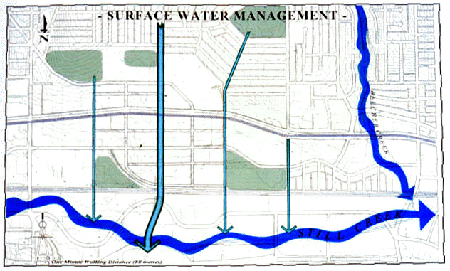
| Example 1 illustrates a proposed strategy for surface water management.
The neighbourhood design addresses stormwater management through sensitive
grading. The restored Beecher Creek, Willingdon Avenue, and adjacent
local collector streets are the primary channels for surface water
flow and infiltration. The north-south streets collect water in surface
channels where it can infiltrate before it enters retention areas
and Still Creek. Large recreation areas (such as playing fields) double
as infiltration basins.
Example 2 shows the use of a retention pond system within a residential
neighbourhood in the southeast portion of the site. Water is collected
behind houses in V-shaped channels along back lanes. Infiltration
trenches are incorporated into these trenches. Streetside swales
feed into infiltration beds that frame the communitys working greens.
As with the back lane swales, these and other swales incorporate
infiltration devices and empty into a series of retention ponds
at the edge of the Still Creek corridor. Properly designed retention
and detention systems allow for fine sediment to settle and for
wetland vegetation to absorb some of the dissolved nutrients in
the stored runoff. Retention times in wet basins are commonly set
at one to three days for the removal of fine sediment and at up
to two weeks for nutrient uptake by wetland vegetation.38
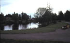
The shape and appearance of retention ponds varies according to
the site context. Some have a natural appearance, while others
may have a more urban appearance (such as the ones shown in the
example). All can become important natural and recreational features
in the Infiltration works best in soils with high to moderate percolation rates: deep, well-drained sand, gravel, or sandy loam with moderately fine to moderately coarse textures. Infiltration techniques are limited where soils have slow percolation rates (i.e., silty loam, or clay) where clogging may occur. High groundwater levels, steep slopes, or shallow bedrock also inhibit adequate infiltration.39 Soils at the Brentwood site are generally heavy on the slopes and peaty on the Still Creek plain. Such soils do not preclude the use of infiltration devices; they would, however, need to be designed according to the specifics of the site. The capacity of the upstream infiltration devices would be frequently exceeded, even though the majority of the precipitation that falls on the site during the typical gentle rainfall, would likely be entirely absorbed. When the capacity of the upstream infiltration system is exceeded, then conveyance swales would direct water to retention facilities. |
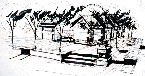
| Open Channels One of the most common infiltration devices is the open channel. Open channels are designed and maintained to slowly transport shallow depths of runoff over vegetation and to provide an opportunity for sediment and particulates to be filtered and degraded through biological activity. All open channels are typically designed to convey the ten-year storm and to prevent critical erosive velocities during the two-year storm.40 These channels can be designed in one of four ways: through a drainage channel, a grassed channel, a dry swale or a wet swale. Drainage channels are designed to handle peak discharges for large storms, to minimize erosion, and to help trap coarse sediment before they are delivered to a downstream pond. Their more important function may be their capacity to allow water to infiltrate into the soils below. Example 3 shows a type of hard-surface drainage channel proposed for the rear lanes of a residential neighbourhood. Because of the density proposed for this area, it was suggested that a surface more durable than grass would be needed to keep water on the surface and to maintain the integrity of the urban street. Through these channels, surface water is conveyed to central greens and southwards to the Still Creek basin. Infiltration would continue to occur through crushed-stone, rilled-french-drain trenches installed below the channel. Grassed channels (also called swales, bio-retention swales, biofilters, or grass swales) discharge to receiving streams and are designed to meet runoff velocity targets under a variety of storm conditions. Generally, they keep water for up to ten minutes and are effective at removing some sediment and hydrocarbons. The channels have broad bottoms and dense vegetation that seem to make them more like drainage channels. Grassed channels are applicable to low- to medium-density development and roads, have few environmental concerns, and are less expensive to construct than are conventional curbs and gutters. Dry swales have the highest water removal rate of any open channel system.41 Runoff is stored in approximately seventy-five centimetres of swale soil (50 percent sand, 50 percent loam) before it is collected by an underdrain (a longitudinal perforated pipe that keeps the swale dry after storm events). Dry swales are the preferred open channel option for most residential settings, since they are designed to prevent standing water problems that often generate homeowner complaints. |
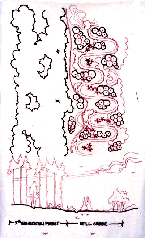
| Unfortunately, they cost more than grass swales and, if the engineering is flawed, they can remove stormwater before it has sufficient time to percolate into the soil. Example 4 depicts how the concept of the dry swale is applied to the specific conditions of the site. Derived from the sites existing soil characteristics, surficial geography, and topography, these dry swales would drain water into the restored Still Creek corridor. Tree canopies and other urban vegetation provide a natural filter and sponge for rainwater and supply the soil with valuable nutrients. Swales along boulevards are filled with peat in order to filter contaminated runoff before it is drained through crushed, recycled concrete. This layer of crushed concrete essentially serves the same purpose as an underdrain pipe, ensuring that the swale dries quickly after storm events. |
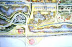
| Wet swales function as a long and linear pocket wetland. They are
usually installed in areas where the water table is close to the surface
and soils are fully saturated most of the year. Wet swales can reduce
sediment, hydrocarbon, loading and metals in most situations.42
The concept of the wet swale is applied to the Willingdon Avenue right-of-way, shown in Example 5. Within a concave median, a landscaped swale is designed to treat first-flush runoff (which carries a high concentration of trace metals and other pollutants) from the street surface. Vegetation planted around its periphery provides bioremediation and functions as a green link to the surrounding open-space system. One of the most cost effective (but land intensive) BMPs is to
preserve a wide riparian corridor around receiving streams. This
type of non-structural system utilizes existing natural features
and is particularly applicable to the charrette site. A buffer helps
to distance areas of impervious cover from a stream corridor and
reduces drainage problems on local properties, thus reducing erosion
and providing continuous terrestrial habitat for wildlife (including
amphibians and waterfowl). It has been shown that two kilometres
of a twenty metre buffer provides ten to sixteen hectares of habitat
along shorelines. Riparian vegetation also helps in shading urban
streams while leaf litter and woody debris provide cover and a more
complex habitat for fish. An unbuffered urban stream can heat up
one to five degrees Centigrade above normal, affecting insects and
salmonids.43 |
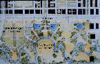
| Example 6 illustrates the relationship between the Still Creek corridor
and the surrounding vegetative buffer. By changing the morphology
of the stream both vertically and horizontally (through riffles
and meanders) more surface area is covered by the stream, and small
pools for egg hatching and refuge are created. The forested edge provides
organic woody debris for waterfowl and fish habitat, and the extensive
buffer area also provides a filter for urban runoff before draining
into the stream course.
Wetlands |
| Wetlands are moderately to highly effective with regard to pollutant
removal, provide very good wildlife habitat, and are applicable to
most developments if enough land is available. With clever design
they can provide long-lasting recreational benefits and educational
opportunities in addition to a productive ecosystem.47
A 1984 survey indicated positive public attitudes towards wetlands.
Over 98 percent of respondents used the artificial sites for wildlife
viewing, and 94 percent said it is important to manage these areas
for fish and wildlife as well as for flood and sediment control (if
technically and economically feasible).
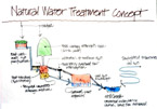
Approximately 73 percent would pay more for property located near an artificial wetland, and benefits seemed to outweigh drawbacks.48 At the southern edge of the site, constructed wetlands are incorporated into a larger area devoted to bioremediation and energy re-use (Example 7 and 8). In Example 7, sewer effluent is pumped from the Crystal Palace to primary treatment ponds in the nearby cloverleaf of the Trans-Canada Highway from which it flows to a constructed wetland for purification. From there it joins the stormwater runoff, which has coursed down the slope and been collected in a large wet swale north of the railroad tracks and directed under the rail bed to the large wetland. Studies suggest that sediment buildup, accumulation of pollutants, and leaching of toxins are some potential drawbacks of wetlands. However, with most of the runoff from the site being absorbed in the upstream infiltration devices, and given the numerous upstream natural swales (where sediments would drop out), it is speculated that the wetlands incorporated into the charrette designs would last many times longer than would wetlands attached to conventional pipe systems. Conclusion |
| Notes
1 Shira B. Golden, Ecological Infrastructure in the Brentwood Town Centre: Implications of a Design Charrette on Stormwater Management. Unpublished Masters Thesis. School of Resource and Environmental Management. Simon Fraser University. 1999. 2 L. G. Smith, T.J. Carlisle, and S.N. Meek, Implementing Sustainability: The Use of Natural Channel Design and Artificial Wetlands for Stormwater Management Journal of Environ-mental Management 37(1993): 241-57. 3 Ibid. 4 C.L. Girling and K.I. Helphand, Retrofitting Suburbia: Open Space in Bellevue, Washington, USA, Landscape and Urban Planning 36 (1997): 301-13. 5 T. Richman and Associates, Start at the Source: Residential Site Planning and Design Guidance Manual for Stormwater Quality Protection (Bay Area Stormwater Management Agencies Association, 1997). 6 T. Schueler, Site Planning for Urban Stream Protection (Portland: Metropolitan Washington Council of Governments and the Centre for Watershed Protection, 1995). 7 R.L. Thayer Jr. and T. Westbrook, Open Drainage Systems for Residential Communities: Case Studies from Californias Central Valley, CELA 89. Proceedings, Council of Educators in Landscape Architecture Annual Conference, 7-9 September 1989, Amelia Island, Florida. 8 Richman, Start at the Source. 9 J.T Tourbier,Open Space Through Stormwater Management, Journal of Soil and Water Conservation 49, no. 1 (1994):14-21. 10 Schueler, Site Planning for Urban Stream Protection; Chester Arnold Jr. and C. James Gibbons Impervious Surface Coverage: The Emergence of a Key Environmental Indicator, Journal of the American Planning Association 62, no. 2 (1996): 243-58. 11Arnold and Gibbons, Impervious Surface Coverage. 12 P. Condon, Alternative Development Standards for Sustainable Communities: Design Workbook (Surrey, BC: Fraser Valley Real Estate Board, 1998). 13 Richman, Start at the Source; Chester and Gibbons, Impervious Surface Coverage; Schueller, Site Planning for Urban Stream Protection. 14 Galli, as cited in Schueler, Site Planning for Urban Stream Protection. 15 Adapted from Schueler, Site Planning for Urban Stream Protection; Tourbier, Open Space Through Stormwater Management; J. Eisen, Toward a Sustainable Urbanism: Lessons from Federal Regulation of Urban Stormwater Runoff, Journal of Urban and Contemporary Law 48, no. 1 (1995):1-86; Still Creek Brunette Basin Work Group, Still Creek-Brunette Basin Issues and Proposed Actions (Burnaby, BC: BCIT, Westwater Research, 1996). 16 Richman, Start at the Source; Site Planning for Urban Stream Protection; Tourbrier, Open Space through Stormwater Management; Smith et al., Implementing Sustainability. 17 T. Korsiak and G. Mulamoottil, Stormwater Management Measures in Ontario: Status and Problems in Implementation, Canadian Water Resources Journal 11, no. 4 (1996):5-15. 18 City of Burnaby, Official Community Plan (Burnaby, BC: City of Burnaby Planning and Building Department, 1998). 19 City of Burnaby, Byrne Creek Watershed Stormwater Management Study (Burnaby, BC: City of Burnaby Engineering Department, 1997). 20 City of Burnaby, State of the Environment Report for Burnaby (Burnaby, BC: Environment and Waste Management Committee, 1993). 21 There are seven recognized ESAs within the Brentwood site. These include: Still Creek; several unnamed creeks; the Beth Israel and Masonic Cemeteries; the CNR/Burlington Northern Railway right-of-way; Springer Park; and a second growth block of forest. These sensitive areas are important because they support varied habitat and maintain the hydrologic function of the site. They also support the wildlife and habitat reserve located around Burnaby Lake and the Brunette Basin. 22 Schueler, Site Planning for Urban Stream Protection. 23 Thayer and Westbrook Open Drainage Systems for Residential Communities. 24 Condon, Alternative Development Standards. 25 D. Butler and J. Parkinson, Towards Sustainable Urban Drainage, Water, Science and Technology 35, no. 9 (1997):53-63. 26 Smith et al, Implementing Sustainability. 27 Condon, Alternative Development Standards. 28 Thayer and Westbrook, Open Space Systems for
Residential Communities. 30 Arnold and Gibbons, Impervious Surface Coverage. 31 Lanarc Consultants, Stream Stewardship: A Guide for Planners and Developers (Nanaimo, BC: Ministry of Environment, Lands, and Parks and Ministry of Municipal Affairs, 1994). 32 A.I. Lawrence, J. Marsalek, J. Ellis, and B. Urbonas, Stormwater Detention and BMPs, Journal of Hydraulic Research 34, no. 6 (1996): 799-813. 33 Eisen, Toward a Sustainable Urbanism. 34 Richman, Start at the Source. 35 Lawrence, Marsalek, Ellis, and Urbonas, Stormwater Detention and BMPs. 36Richman, Start at the Source. 37 Ibid. 38 Ibid. 39 Ibid. 40 Ibid. 41 Schueler, Site Planning for Urban Stream Protection. 42 Ibid. 43 Ibid. 44 T.J Carlisle and G. Mulamoottil, Artificial Wetlands for the Treatment of Stormwater, Canadian Water Resources Journal 16, no. 4 (1991):331-43. 45 Smith et al., Implementing Sustainability. 46 Ibid. 47 Carlisle and Mulamoottil, Artificial
Wetlands for the Treatment of Stormwater. |
|
The
basis for this chapter is a
Masters thesis granted by Simon Fraser University in 1999, Ecological Infrastructure in the Brentwood Town Centre: Implications of a Design Charrette on Stormwater Management 1, by Shira B. Golden.
|
|
Table
1 |
|
Table
2 |
|
|
Example 4 |

Example 5 |