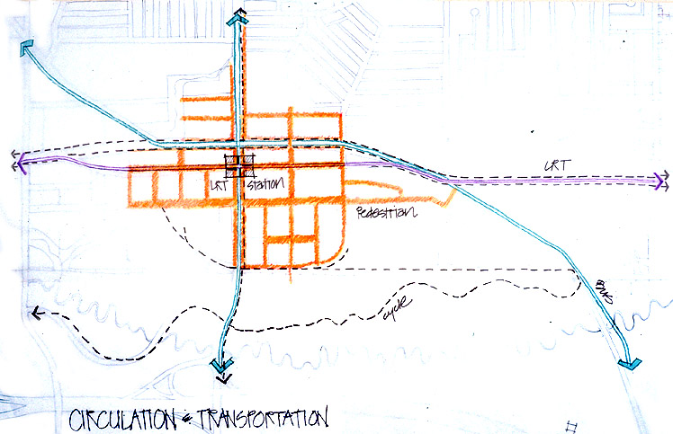
Circulation
and Transportation
The
circulation plan shows the hierarchical organization of paths
and networks for the site. Light rail is separated from Lougheed
Highway and aligned along Dawson Street (the pedestrianized
High Street) to the south. This realignment allows light rail
to be more continuously connected to the community and avoids
a major grade change at the intersection of Lougheed Highway
and Willingdon Avenue. Bus, auto, and bike traffic is accommodated
along the Lougheed corridor. To the south, a finer-grained
grid of neighbourhood streets, designed to human dimensions,
encourages walking and cycling to local destinations.
 back
back
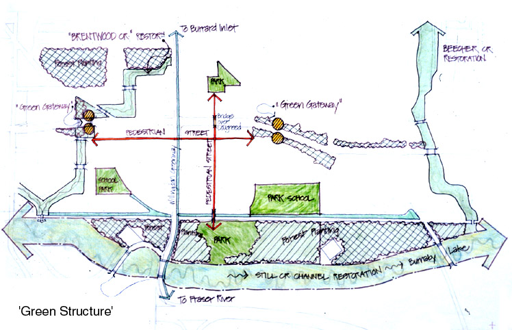
Green
Structure
Here,
general patterns of circulation are overlaid with an open-space
structure with a view to enhancing ecological linkages both
inside and outside the site. The restoration of previously
culverted streams re-establishes important aquatic and ecological
connections that are central to the sites history. At one
level, these green connections serve as wildlife and recreation
corridors, linking the site to the restored Still Creek and,
ultimately, to Burnaby Lake. At another level, these connections
support existing corridors and patches of urban vegetation,
examples being the green gateways that mark the entries
to the site and the coniferous forests that line the Still
Creek valley.
back
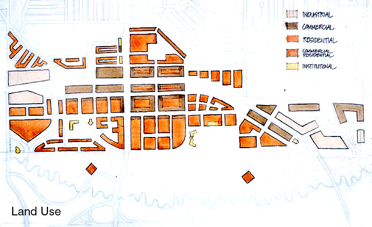
Land
Use
Consistent
with the local area plan for Brentwood, two community hubs
are proposed: one along the Lougheed corridor that would serve
passing traffic, and one along the High Street that would
cater to local residents and pedestrians who arrive by transit.
Each are enlivened by commercial uses at street level and
high-density residential towers. In the northeast corner,
Brentwood Mall is decommissioned and replaced by medium-density
attached town houses. South of the commercial core the finer-grained
grid features medium-density courtyard housing and row houses
within walkable neighbourhoods. Along the edges, larger blocks
of medium-density housing are surrounded by open space. Institutional
uses are proposed around the central core of the community
and are integrated within the larger open-space structure.
back