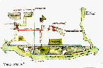
Still Creek
|
Wildlife
|
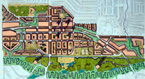
The mantra that guided
this design was: a healthy city equals a healthy ecosystem. We
felt that the key to achieving this balanced equation lay in achieving
a high density of residential and commercial development that was
centred just to the south of the Lougheed corridor and just to the
east of Willingdon Avenue. Once this core decision had been made,
the principles that shaped our urban design followed inevitably.
These principles can be summarized as: (1) separating the light
rail from the highway; (2) relocating the shopping core to the south
side of Lougheed Highway; (3) establishing a high-density residential
core around the light rail station; (4) creating green fingers connecting
north and south throughout the site; and (5) faithfully restoring
the morphology and ecology of Still Creek and its valley.
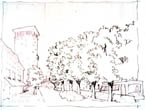
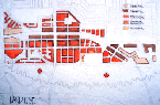
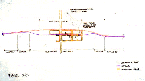
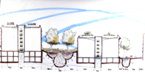
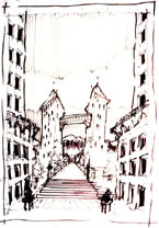
Twin
Arteries: The Highway and the Transit High Street
Unlike the other teams, we separated the light rail line in the
core of the new town centre from the Lougheed corridor. This separation
was intended to accomplish three objectives: (1) to allow the creation
of a pedestrian precinct around the light rail station; (2) to integrate
transit more closely into the fabric of the new Brentwood Town Centre;
and (3) to avoid the need for grade separation at the intersection
of Lougheed Highway and Willingdon Avenue. By taking advantage of
existing grades, we could slip the rail line out of its usual path
in the median of the highway into a short tunnel, swinging it into
an alignment one-half block south of Lougheed Highway. The points
at which this separation occurs (just east and west of the town
centre) would announce the new Brentwood urban core and enhance
its identity along the transit corridor. The new light rail alignment
enters the High Street retail core of the new Brentwood Town Centre
(proposed along Dawson Street, south of Lougheed Highway) via a
transit station at Willingdon Avenue. With coordinated traffic signal
controls, trains would be able to cross Willingdon Avenue at grade,
thus eliminating the need for grade separation and so creating a
closer integration of the transit system and the street network.
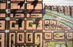
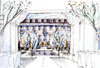
Shifting the Retail Core
In our scheme, the existing, and increasingly moribund, Brentwood
Mall is removed, with shops and services relocated in phases to
High Street and to the south side of Lougheed Highway. This brings
the core of retail and services to the heart of the new community,
while allowing the hilltop site of the mall with its excellent
views to be redeveloped for mixed-density housing. The Lougheed
Highway frontage would include shops and services dependent on passing
traffic. A slow-speed boulevard parking road on either side of Lougheed
Highway would allow access to these shops while also humanizing
the face of this high-traffic highway. Meanwhile, the High Street
would house services catering to local residents and those pedestrians
who arrive by transit. We en-visioned this retail street to include
a mix of service shops, with high-density residential towers set
on the podiums of commercial structures. Connections between the
retail and transit hub would be maintained with the new residential
area north of Lougheed Highway, chiefly by a large pedestrian bridge,
which is aligned with a north-south pedestrian-oriented green street.
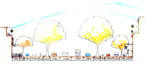
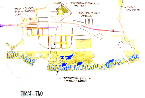
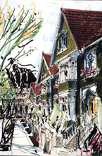
Courtyards and Point Towers: Density and
Quality of Life
We clustered high-density residential development around the urban
core and the transit station. This meant that the bulk of new housing
would occur on the south-facing slopes of Lougheed Highway. In order
to maximize access to the light and warmth of the sun while maintaining
an urban expression along streets, we made extensive use of four-storey
courtyard buildings, arranged in a matrix of short, square blocks.
These courtyard structures would be stepped towards the south, increasing
solar gain into the courtyards and uphill areas. Along both sides
of the Lougheed corridor (between the High Street and the Trans-Canada
Highway) we proposed high-density, narrow point towers. This forest
of towers would announce the town centre, allow many people to live
at the heart of the community, and increase the viability of the
commercial core and the transit line. Outside of this core zone,
housing would be primarily ground-oriented row housing, garden apartments
and narrow-lot semi-detached housing. The market demand for this
housing type is strong in the region, encouraging a mix of new residents.
Also, we felt that it was important to meet the existing detached
housing surrounding the site in a sympathetic manner.
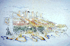
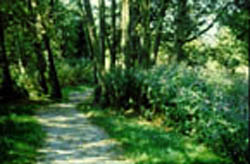
The Green Structure
An integral part of our scheme was to stitch together the town centre
by using lineaments of green spaces to join the uphill urban centre
with the restored natural landscapes of the Still Creek valley.
A heavily planted greenway/bikeway corridor along the east side
of Willingdon Avenue acts as a continuous natural corridor that
will eventually connect this neighbourhood with Burrard Inlet to
the north and with the Fraser River to the south. On a more local
scale, a planted, pedestrian street bisects the site from a forested
park at the crown of the hill (the existing location of the Brentwood
Mall) to the central valley. Blocks of forest are used as gateways
to define the new urban centre, distinguishing it from the succession
of developments that will form along Lougheed Highway and the light
rail corridor. These green gateways are concentrated along Lougheed
Highway and the rail line, as well as in the Still Creek valley.
Several historical streams that have been culverted over the years
are daylighted. The health of these daylighted streams is ensured
by densely planted, water-cleansing riparian strips on either side.
Finally, we developed a system of ecological infrastructure: trenches
filled with peat soils and with crushed recycled concrete that receive
rainwater from roofs and pavements. These trenches serve to reintroduce
water into the ground, and act as natural sponges to slow the flush
of stormwater into the restored Still Creek. Planting of wetland
plants and grasses along these trenches remove pollutants from the
stormwater runoff.
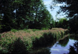
Restoring Still Creek
As part of a larger initiative to restore the health of Burnabys
central valley, we restored Still Creek based on a careful analysis
of its morphology, gradient, sediment load, and hydrological condition.
The resulting creek form is tightly meandering, with a very low
bed gradient and a low velocity of flow. By creating high-density
development on the uphill portion of the site, we were able to completely
set aside the valley, replanting it with a native cedar-hemlock
forest. The peat channels, and restored and daylighted streams that
feed storm runoff from the site into the valley, will be reinforced
by constructed wetlands in the peat lowlands that flank the creek,
further purifying the stormwater and protecting the creek itself.
Non-intensive uses, such as community gardening and passive recreation
areas, are located on the fringes of the valley. Through land-swapping
and density bonus incentives, current industrial and corporate structures
will be encouraged to relocate outside the valley.
Conclusion
In summary, we believe that the strategic principles that undergird
this scheme would lead to a balance between a healthy urban core
and a healthy ecosystem. The high-density development of the site
(higher than that called for in the design brief for the charrette)
will pay dividends in the form of the restoration of Still Creek.
The ecological infrastructure will reduce capital expenditure in
sewers and water treatment, while also contributing to the creation
of a more livable community. The creation of a viable, pedestrian-oriented
commercial and transit core will draw people away from their dependence
on automobiles, thus enhancing the health of the region and the
social fabric of the community.
next page
|