for Sustainable Communities
with an ecological underlay
Characteristics of form
|
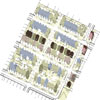
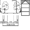
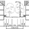
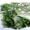
Density: There are 47.7 dwelling units per hectare (19.3 dwelling units per acre) in this case study site, with 4,767 dwelling units per square kilometre, or a total population of 11,918 people per square kilometre (assuming an average of 2.5 people per dwelling unit). After allowing as much as 40% for open space, ecological infrastructure, and non residential uses throughout the district, we estimate that this pattern would accommodate 7,557 persons per square kilometre. This density is thirty percent higher than the Traditional Pattern case study and over three times higher than that of the Status Quo case study site. Infrastructure: Of the total site area, 26 percent is paved road, driveway, garages, parking pad, or sidewalk. This produces 51 square meters (549 square feet) of pavement per dwelling unit (either on it or directly adjacent to it). In some cases private walks extend from the street to the rear unit through the side yard. There are, on average, 10 square meters (108 square feet) of paved surface per dwelling unit. As with the Traditional Pattern, private, paved driveways are uncommon.. Cars are stored off gravel lanes located behind dwelling units. The storm drain system in the Traditional Pattern with an Ecological Underlay is entirely natural. Street-side swales feed into retention swales which frame the community gardens. Excess water slowly re-enters adjacent natural streams which are preserved to receive water. This slow filtration process helps to cleanse the water and prevent flooding. Streamways double as bikeways, walkways, and natural recreation areas. The utility infrastructure of the Traditional Pattern with the Ecological Underlay follows roads and lanes. There is, on average, 3.8 metres (12.5 linear feet) of utility run per dwelling unit. Gas lines are buried in the lanes while electric, telephone, and cable television lines are held aloft on poles also located in the lane. Sanitary and water mains are buried in the street right-of-way. The surface storm drain system eliminates the need for a sub-surface storm drain system.
Coverage and Permeability: On average, 14 percent of each individual lot is paved sidewalk with a further 36 percent covered by house, carriage house, storage, garage structures and/or paved car pads. Fifty percent of the total site is permeable surface which includes lawn, planting beds, street shoulders and unpaved lanes. Recreation Space: Local recreation space is provided by nearby schools, neighbourhood parks, and riparian strips associated with preserved natural streams and swales. These provide a mix of field and court sport areas as well as natural areas. Assuming a a10 minute walking radius, there are approximately 18 square meters (194 square feet) per dwelling unit of recreation space located in the immediate neighbourhood. On average, it would take 1 minute to walk to the nearest recreation area (assuming a pace of 1 kilometre per 5 minutes). Virtually 100% of residents are located within a 5 minute walk to the closest recreational space.
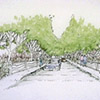
Multi-Modal Transportation: The preserved streamways in the district also include ike and walkways; thus, virtually every part of the community is accessible via this system which, in combination with the gridiron street system, provides complete intra- and inter-community access. |
|||||||||
Click to view detail
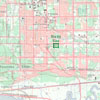
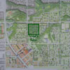
Community Context