|
|
|
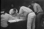
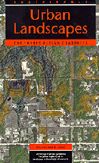
In August 1997, four design
teams made up of landscape architects, architects, and students
in these disciplines assembled to illustrate what a sustainable
Brentwood Town Centre might look like. This document reports the results
of that event. Divided into three sections this report includes: first,
an introduction outlining the charrette process and an overview of
the sites economic, social, and physical geography; second, a detailed
synopsis of the four teams options and subsequent recommendations;
and third, a discussion of three issues central to sustainable community
design in sites like the Brentwood Town Centre.
The Brentwood Design Charrette is a project of the University
of British Columbias James Taylor Chair in Landscape and Liveable
Environments. This Endowed chair was formed by University of British
Columbia (UBC) in 1994 in direct response to the 1987 United Nations
World Commission on Environment and Development, which, in its assessment
of the state of the global biosphere, concluded that the solutions
to many global environmental problems are to be found at the local
level and, particularly, at the individual site-development level.
Operated through the Landscape Architecture Program at UBC, the
chair is dedicated to advancing both the scholarship and practice
of sustainable design. The chairs primary goal is to illustrate
what our neighbourhoods and communities could look like if they
were designed and built in conformance with emerging local, provincial,
and federal policies regarding sustainable development. This
goal is underpinned by the following important principle: the individual
site, and even the individual house and yard, are to the landscape
region what the single cell is to the human body. Just as the health
of the human body is dependent on the health of all its cells, so
the ecological health of a landscape region is dependent on the
health of its individual sites.
|
The
Charrette Process
The term charrette was coined nearly 100 years ago at the Ecole des
Beaux Arts in Paris. Students enrolled in the School of Architecture
were expected to meet strict deadlines for the completion of often
impossibly complex design problems. When the deadline arrived, a small
cart (in French, a charrette) was wheeled past students to collect
their drawings. In its original context, the charrette represented
the inevitable end of the students design process; in its current
context, the charrette still represents an end, but the end of only
the first step.
Over the past few years, charettes have become an important part
of the public planning process. The UBC charrettes are intended
to illustrate the very real implications of written policy and to
bring it to life through pictures. In this way, teams of designers,
rather than drawing representations of their own particular and
sometimes peculiar ideas, use democratically arrived at policies
as the sole basis for their designs.
Our charrette occurred within a very compressed time period and
included a number of design disciplines. Because of this there was
an intensity of creative energy, focus, and initiative that resulted
in the hundreds of images that make up this report.
As a cautionary point, given the short time in which they were
produced, no one should think of the designs as complete. These
designs are beginnings, not ends. They provide a point of departure
for later contemplation and elaboration. In short, they provide
the pictures of what a more sustainable future for this site might
look like nothing more.
|
Goals
and Objectives of the Brentwood Charrette
The goal of this project is: |
To
demonstrate what the Brentwood Town Centre could look like if it
were designed and built in conformance with emerging local, provincial,
and federal policies regarding sustainable development.
|
The above-stated goal suggests
the following more specific objectives:
1. To produce sustainable community design models for
the Brentwood Town Centre.
2. To illustrate the design consequences of meeting disparate and
often contradictory sustainability policy objectives.
3. To illuminate the connection between sustainability and livability
when redeveloping areas of this type.
4. To show how sustainable design objectives are influenced and/or
impeded by typical community subdivision, site, and traffic engineering
regulations.
5. To create a setting in which leading British Columbia designers
and outside experts can exchange ideas and viewpoints concerning
how first-ring suburban commercial areas might be retro-fitted.
6. To produce design proposals that may provide patterns, processes,
and prototypes for Brentwood and the many other similar sites throughout
North America.
7. To broadly distribute the results of the Brentwood charrette
through a variety of means and venues to citizens, elected representatives,
policy makers, students, and designers and thereby influence future
public policy and legislative initiatives.
|
The Charrette Sequence
The Brentwood charrette is the second in a series of UBC-sponsored
charrettes focusing on sustainable urban landscapes. The choice of
sites for the series is not based on any one single criterion but,
rather, is informed by the confluence of several factors. These include
a supportive political climate, a well developed policy framework,
and the presence of diverse physical and sociocultural landscape characteristics
common to many other communities in British Columbia and beyond, ensuring
that solutions are transferable.
The first charrette, held in the summer of 1995,1
focused on a 400-acre green-field site in the South Newton District
of Surrey, located on the periphery of the expanding metroplex.
A site with its natural systems more or less intact and relatively
few constraints to development, it presented designers with a relatively
clean slate.
The second site, located in Burnaby, was selected to test the
principles of sustainability within a 590-acre medium-density first-ring
suburban commercial strip. Given that this site was already completely
developed and nearing the end of its first economic life, the design
challenge lay in accommodating projected housing demand and commercial
capacity in a way that would establish transit-oriented, identifiable
neighbourhoods while maintaining (or potentially enhancing) existing
ecological systems. A strong factor influencing the choice of the
Brentwood site was the existence of The Brentwood Town Centre
Development Plan 2, which
was completed in 1996 by the City of Burnaby in conformance with
the Greater Vancouver Regional District (GVRD) "Livable Region"
sustainable planning goals.3
|
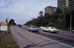
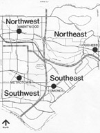
Why
this Type of Site
Like many other North American first-ring suburbs, Burnaby was originally
an edge but is now a centre.In Burnaby, and in many similar cities,
automobile-oriented commercial strip developments are nearing the
end of their first life cycle and are poised for regeneration. Sites
such as these have low net densities, with development dispersed across
a relatively large land area. This under-utilized land resource presents
an opportunity to meet local and regional goals through more intensified
land use. At the same time, because of the tendency of these zones
to be on or near flat land, they are often also on or near sensitive
aquatic systems. Typically, these systems support many important terrestrial
and aquatic species.
A number of opportunities are inherent within such a site. Densification
is typically less contentious here than it is in existing residential
or older commercial areas, where concern for such issues as traffic,
heritage conservation, and neighbourhood livability often become roadblocks
to change. Moreover, as distance from the high-amenity metropolitan
core increases, land values tend to decrease, making development more
affordable. However, as they are still close to the metropolitan core,
these areas typically have large population catchments that are able
to support a more intensely developed town centre.
|
|
|
Site
Context
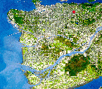
Geographically located at the centre of the Greater Vancouver Region,
Burnaby encloses approximately 4 percent of the regions land area
and accommodates 11 percent of its population, giving it approximately
three times the average density of the metropolitan region as a whole.
Burnaby is located within the Burrard Peninsula, a subregion identified
by largest share of the regions anticipated growth over the next
twenty-five years.4
|
Development
Pattern
Burnabys early development was governed by three things: the existing
landscape structure, organic development, and the gridiron. The landscape
structure is distinguished by a hill/valley/ridge terrain, which produces
a strong east-west trail system and contributes to the concentration
of development along the ridges. The lack of north-south transportation
routes coupled with the existence of difficult soil conditions in
the valleys, made a physical connection through the latter difficult
to achieve, and these areas have remained relatively undeveloped.
However, transportation linkages between New Westminster and Vancouver
stimulated organic development along these routes and the 1860 parcelling
of land into 160-acre lots produced a loose gridiron pattern. The
development pattern that resulted balanced the relationship between
the ordered grid and the natural physical underlay.
Settlement patterns in Burnaby over the twentieth century have
followed those typical of most North American suburbs. Rural settlement
was followed by early urbanization during the 1910s and 1920s. During
the postwar years, suburbanization occurred. In the past two decades
Burnaby has become a more complete community and has been able
to provide jobs for many more of its residents than it has in the
past. With rural aspects, low- to high-density residential areas,
commercial town centres, research parks, major postsecondary institutions,
and rapid transit, Burnaby is positioning itself to become a regional
focus for numerous functions.
|
The
Livable Region Strategic Plan
The Greater Vancouver Livable Region Strategic Plan (1996)
states that a more sustainable region results from: protecting the
green zone, building complete communities, achieving a compact metropolitan
region, and increasing transportation choice.5
The establishment of thirteen Municipal Town Centres is the main
strategy by which the livable region is to be achieved. One of these
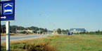
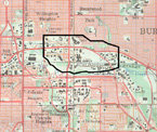
proposed centres is Burnabys Brentwood Town Centre. Located at the
crossroads of two major transportation arterials Lougheed Highway
and Willingdon Avenue and adjacent to the Trans-Canada Highway,
this area has already developed a significant commercial presence
and is recognized in the livable region strategic plan as the locus
of future sustainable redevelopment for Burnaby.
|
The
Brentwood Town Centre Development Plan
The Brentwood Town Centre Development Plan anticipates the eventual
addition of over 9,300 new dwelling units and over a million square
feet of new office and commercial space. The Plan will provide jobs
and services for thousands of those who live nearby or who live along
the new transit line proposed for the Lougheed/Willingdon corridor.6
The new transit system will support higher density development, provide
a modal alternative to conventional auto travel, and, ideally, form
an integral part of the urban realm. |
The
Green Zone
The total area of the site is 590 acres. The Brentwood Town Centre
rests entirely within the Brunette Basin, a watershed region identified
by the GVRD as a Green Zone and, therefore, endowed with special natural
attributes that require protection. A highly residential urban drainage
area, the Brunette Watershed drains into the Fraser River at New Westminster.
Its upper catchments are primarily drained by culverted streams and
storm sewer systems that outfall into open waterways and large open
tributaries like Still Creek. Water quality has become a source of
major concern for Burnaby, as increasing levels of non-point pollution
threaten local water sources.7 Recent
reports on water quality in the Brunette Basin suggest that rising
populations, increasing non-permeable surface area, and traditional
municipal wastewater management programs will eventually make urban
stormwater runoff the primary source of pollution entering the lower
Fraser River.8 Combined sewers and illegal sanitary connectors
also contribute to water quality problems in urban storm run-off.
Heavy rainfalls may result in runoff rates that exceed the capacity
of the combined system, resulting in overflows that release stormwater
and untreated sewage into natural bodies of water.9
In Burnaby, increases in impervious areas, reductions in permeable
surface area, decreased flood storage, culverting of streams, and
encroachment of buildings near river banks have heightened the natural
systems sensitivity to development. Best Management Practices (BMPs)
are being widely suggested as an on-site means of reducing water
system contamination and mitigating the impacts of urbanization
on stream corridor ecology. The benefits of BMPs can be measured
by how well they replicate the natural hydrological functioning
of the site through alternative stormwater management strategies.
The incorporation of BMPs was considered essential to establishing
a system of ecological infrastructure on the site and to reducing
the burden on the Still Creek water system. A discussion of ecological
infrastructure and specific charrette solutions is provided in a
later chapter.
Presently, few if any, water quality BMPs (such as retention ponds,
grass swales, or infiltration basins) protect Still Creek. While
this aquatic corridor, and its associated green spaces, provide
valuable wildlife and fish habitat, it is impacted by the Trans-Canada
and Lougheed Highways as well as by adjacent industrial uses. All
of these factors combine to help make Still Creek one of most polluted
drainage systems in the region.10
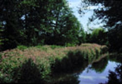
Still Creek is appropriately named. Its shallow gradient produces
a naturally slow-moving, meandering stream characteristics that
affect its ability to absorb urban runoff and to flush out contaminants.
Very soft peat soils line both sides of the stream at depths of
between five and forty feet, making this area difficult to build
on and easy to damage.
|
The
Design Brief
Using slightly modified land-use targets drawn from the Brentwood
Town Centre Plan, the design program called for 9,300 new dwelling
units on 194 acres of land, with a proposed community of 16,500 persons.
A wide variety of housing types, appropriate for many family types
but with a special emphasis on ground-oriented homes, was required.
The provision of light rail along the Broadway/Lougheed corridor was
assumed, as per the then current Provincial plans. The program required
significant attention to the placement and design of a major transit
node, as well as the placement, design, and frequency of connectors,
via other modes of transportation, to this node. Overall, the goal
was an integrated community, one in which people would be able to
live, work, shop, and have access to transit within identifiable neighbourhoods.
|
Three
Special Concerns
The above highlights the opportunities and constraints of the Brentwood
site, many of which are typical of other sites in the Greater Vancouver
Region and, indeed, throughout North America. These existing conditions,
together with the design program, provided the framework within which
charrette participants were to explore three very important questions:
1. How can we create strong, inclusive, and
diverse neighbourhoods made up of medium-density
ground-oriented homes?
2. How can we add density in a way that improves, rather than
degrades, environmental quality.
3. How can we creatively integrate light
rapid transit into the fabric of the community in
a way that unites, rather than divides, it?
The designers were asked to pay particular attention to these three
questions. We have aggregated their responses and insights in the
concluding sections, where each of these crucial questions is taken
up in turn.
next page
|
Notes:
1 Patrick M. Condon, ed. Sustainable Urban
Landscapes: The Surrey Design Charrette (Vancouver, BC: University
of British Columbia James Taylor Chair in Landscape and Liveable Environments,
1996).
2 City of Burnaby, Brentwood Town Centre
Development Plan (Burnaby, BC: City of Burnaby Planning and Building
Department, 1996).
3 The Greater Vancouver Regional District
(GVRD) is a provincially enabled public agency that is, among other
things, charged with coordinating growth in the Vancouver metropolitan
region. Certain of the key documents informing the design program
were produced under the direction of the GVRD, notably, The Livable
Region Strategy (1990) and The Livable Region Strategic Plan (1996).
4 Greater Vancouver Regional District,
The Livable Region Strategic Plan: Managing Greater Vancouvers
Growth. (Vancouver, BC: Greater Vancouver Regional District, 1996).
5 Ibid.
6 City of Burnaby, Official Community
Plan for Burnaby British Columbia (Burnaby, BC: City of Burnaby,
1987).
7 At the time of the charrette, light
rail was proposed along the Broadway corridor. In early June1998,
the Province of British Columbia announced that it would abandon
plans for surface light rail along this route in favour of an expansion
of the Skytrain, or elevated advanced light rapid trasit (ALRT),
system. While the implications of this precipitous decision are
yet to be fully understood, the images in this report provide a
number of arguments that support surface light rail.
8 Ron MacDonald, K. Hall, and H. Schreier.
Water Quality and Stormwater Contaminants in the Brunette River
Watershed, British Columbia, 1994/1995, Final Report (Vancouver:
University of British Columbia, Westwater Research Unit, Institute
for Resources and Environment, 1997).
9 Non-point source pollution is so named
because it is pollution that enters waterways from no single, traceable,
and regulated source (i.e., sewage outfalls, industrial waste) but,
rather, flows over the land as a result of the varied by-products
of urbanization. Contaminants from non-point source pollution include
pathogens (disease-causing microorganisms), nutrients, metals, and
debris. As point source pollution is increasingly brought under
control, non-point source pollution is becoming the leading threat
to water quality in urban areas.
10 Reid Chamberlain, C. Guss, P. Unruh,
and C. Williams, Best Management Practices Plan for Still Creek
in the Brunette Watershed, Final Report (Burnaby, BC, 1996).
11 City of Burnaby, The State of the Environment
Report for Burnaby, (Burnaby, BC: City of Burnaby Environment and
Waste Management Committee, 1993).
12 The complete program is included in
the appendix, and a careful review is recommended.
|
|