| The Greater Vancouver Region is yearly becoming
more car dependent. In fact, the car accounts for the majority of
trips in the Vancouver region and over 70 percent of all daily travel.1
Between 1985 and 1992 the number of commuter cars grew 16 percent
more than did the population. Meanwhile the average number of people
per car went down, and the number of cars insured for community to
work went up by 32 percent. The average person is travelling more
frequently, for longer distances, and more slowly.2
Since the 1970s, the GVRD, through its Livable Region Strategy, has
established a planning framework for the region that links the development
of higher-density, mixed-use suburban town centres with transportation
investment in order to stabilize and reduce dependence on single-occupant
vehicles.3
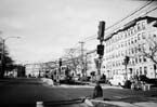
In many North American cities the preferred means of promoting concentrated development is through government-financed transit improvements. Increasingly, surface light rail systems are the transit system of choice. Conventional light rail transit (LRT) systems consist of electrically powered trains operating either on existing rail tracks or within an existing street right-of-way. LRT is a common feature of many European cities and North American cities that have recently built entirely new LRT systems include Calgary, Edmonton, and Portland. In the mid-1990s, as part of its ten-year plan, BC Transit 4 proposed a surface light rail along two major corridors within the Greater Vancouver area. The Broadway/Lougheed corridor was one of these. It would connect Vancouver to a number of municipal town centres, including Burnaby. This new system would support and enhance existing transit systems, which consist of an elevated Automated Light Rail Transit (ALRT) system (known as SkyTrain), a fleet of motorized buses and electric trolley buses, a cross-harbour ferry system, and a commuter rail line. It was decided to locate the LRT along the two identified corridors because of above-average growth projections for the contiguous areas as well as because of the current difficulty residents have in smoothly accessing regional shopping and employment centres. Within this context, it was thought that LRT would be the most cost-effective way to shape land use along the transit corridors, to increase density, and to add value around transit stops. Since the charrette, the provincial government has abandoned plans
for surface LRT in favour of expanding the existing SkyTrain transit
system. The charrette designs seen below are based on the original
premise which was that a surface LRT line would run through the
site along the Lougheed corridor and would be a catalyst for significant
future development. They show how teams wrestled with the inherent
complexities of the then current plans for LRT and, more important,
how they confronted the challenge of making transit unite, rather
than divide, communities. While significant debate still rages with
regard to the provinces precipitous change in plans, the decision
to proceed with SkyTrain seems irreversible. However, the charrette
still sheds significant light on how a surface rail system can and
should be incorporated into the urban fabric, if not in the Brentwood
area, then perhaps in other parts of Vancouver and certainly in
other North American communities communities that may have a better
sense of the cost-effectiveness and positive urban design implications
of surface light rail systems. |
| Charrette designers challenged the preliminary city
proposal plans for surface light rail, which suggested ever wider
streets to accommodate transit along the Lougheed corridor. According
to typical road network design standards, Lougheed Highway, as a primary
arterial, should have no fewer than six travel lanes and should be
at least 25.6 metres (78 feet) wide. However, maximum lane widths
were proposed in many sections of the Lougheed corridor. Along some
sections, up to 45 metres (150 feet) of paved road surface was allocated
between sidewalks a width that would accommodate six lanes of auto
traffic going in both directions, two bike lanes, and an 8 metre right-of-way
for surface light rail.5 Turning lanes
averaging 3.7 metres proposed at most intersections would further
widen the paved roadway.
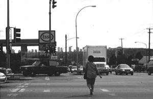
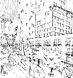
In contrast to Lougheed Highway, Granville Street, a similar type of arterial in the City of Vancouver, carries equally high volumes of traffic, yet does so within fewer and narrower travel lanes. The photo at the lower right shows Granville Street where it passes through the community of Marpole. Here, a dense concentration of neighbourhood shops and offices line the busy street. The volumes of traffic that pass through this area do not irretrievably compromise pedestrian comfort. Curb parking at non-peak hours, pedestrian-controlled traffic signals, and minimum lane widths force cars to move at a reasonable pace. An approximately 28 metre (85 feet) right-of-way consists of six travel lanes with curb lanes accommodating parking at non-peak times. Left turn bays are limited to only one intersection. Charrette designers took streets such as Granville as their cue and proposed minimum lane widths for autos and transit within six travel lanes of traffic travelling in both directions. All proposals were based on the premise that travel speeds along Lougheed Highway can and should be cut in order to secure a safe and attractive urban environment. All four final designs favoured transit and pedestrians over the automobile. Designers adhered to the premise that adding capacity for cars on Lougheed Highway would only attract more traffic from the Trans-Canada Highway during rush-hour periods (which occur twice a day for increasing durations). Designers generally felt that a coordinated strategy of actually increasing travel times for autos, while decreasing travel times for transit, is a crucial and unavoidable aspect of any attempt to shift users from cars to transit. As one designer adamantly declared, Allow cars, but let them crawl! Early government proposals for the Lougheed corridor assumed that
a grade separation was required at the intersection of Lougheed
Highway and Willingdon Avenue. The basis for this assumption lay
in a concern over the efficient movement of traffic across this
major intersection. Often, expensive decisions are made to elevate
or lower transit lines at some or many intersections. This can double
the cost of the system while also making it more difficult to integrate
grade separations into the fabric of the community. In response,
all four teams chose to use at-grade stations as a means of reducing
structural costs, increasing activity on the street, and giving
transit priority over the car. |
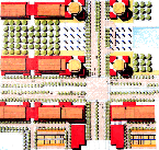
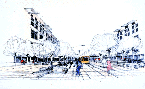
| Charrette Solutions
The four teams treated the alignment of light rail and the location of transit stops in a variety of ways. Teams One and Two chose to place the rail line down the central median of the Lougheed Highway right-of-way between landscaped boulevards. The first four sketches show how stations are tightly integrated with bus and car traffic and pedestrian sidewalks; links with major bus routes are located a few steps away. Lane widths reflect minimum acceptable design standards for the lowered design speeds anticipated for this dense area, and a large portion of the right-of-way is devoted to pedestrians. On-street parking is provided during non-peak periods, and turning lanes are provided only where necessary (and then in ways that are sensitive to pedestrian crossings). Careful attention to detail through the use of closely spaced trees, low fencing, street furniture, and detailed paving gracefully envelope the stops in space so that they are clearly identifiable components of the public realm (see Examples 1-4). Team Two addressed pedestrian safety and movement across the right-of-way by placing a covered stop just east of the Willingdon Avenue/Lougheed Highway intersection (see Example 5). Its streamlined design and steel and glass construction suggests an elegant transit stop rather than a bulky station, and at the same time, provides physical protection from wind, rain, and passing traffic. The street section featured in Example 5 shows how the surface of the street is maintained from sidewalk to sidewalk, allowing the human scale of the train to actually reinforce the pedestrian realm. All too often, transit is treated as a separate piece of infrastructure and is spatially separated from other elements of the street; here, and in all other examples, the rail line reads as part of the street. As shown, the proposed train has a very low profile, with a maximum height that is even lower than that of low-profile buses. In Example 6, Team Three proposed that the entire transit right-of-way be shifted to one side of the street, allowing passenger movement to occur in much the same way as it does at a bus stop. This solution maintains the integrity of the street surface. The street remains relatively undisturbed by structural and grade changes like those required for an elevated station. Travelling at curbs edge, the train itself becomes a pedestrian-scaled urban design feature that animates the sidewalk as it serves it, allowing pedestrians to easily become passengers and passengers to easily become pedestrians. As in previous examples, tree canopy, street furniture, lighting, and distinctive paving patterns provide an important spatial envelope for sidewalk drop-off points, while also adding scale and comfort to the pedestrian environment. Team Four chose to pull the LRT southward to a pedestrianized street (see Examples 7-8). In this scenario, the only moving vehicle on the street would be the train. Car trips would be pushed to parallel streets (particularly to Lougheed Highway). In this scheme, Dawson Street, referred to as the High Street, would be the central spine of an open-air mall. This team most directly challenged the then current plans for light rail, which anticipated that this section of the line would pick up speed in order to compensate for the more frequent stops that would be required throughout the more established areas to the east and west. This teams scenario implies that the rail systems most important service is to the neighbourhood, not to the commuters who live in the east and work in the west. It suggests that the current pattern of commuting wont last forever and that it is more important to bring jobs to people than it is to bring people to jobs. It suggests that what is needed is a transit system that safely transports people to wherever they want to go in the urban area without sacrificing urban integrity for illusive gains in trip duration. To accommodate the pedestrian orientation of the street, Team Four proposes that the train run at maximum speeds of less than thirty kilometres per hour in this 1.5 kilometre stretch and then increase speed as it leaves the core. Conclusion |
| Notes
1 Glen Leicester, Light Rail Transit Growth Management in Vancouver, BC, Canada (Vancouver, BC: BC Transit Strategic Planning Department, 1997). 2 Greater Vancouver Regional District, A Long-Range Transportation Plan for Greater Vancouver (Vancouver, BC: Greater Vancouver Regional District and the Province of British Columbia, 1993). 3 One of the cornerstones of the Livable Region Strategy (1976) and its offspring the Livable Region Strategic Plan (1996), is the concept of concentrated growth through the development of regional and municipal town centres. A total of six regional town centres and thirteen municipal town centres have been identified, each of which are intended to be linked with intermediate- and high-capacity transit systems. 4 Vancouvers transit system is a partnership between BC transit, a Crown Corporation wholly owned by the provincial government, and the Greater Vancouver Transit Authority, the regional body representing local municipalities. 5 City of Burnaby, Burnaby Transportation Plan (Burnaby, BC: City of Burnaby, 1995). |
|
|