|
As a way
of implementing Local Agenda 21, all municipalities in Italy
were required to prepare community plans that would apply
sustainable development principles at the local level through
a participatory process, with a focus on the involvement of
marginalized populations (i.e., women, children, and youth).
In 1996,
as part of its "The Future of Empoli" vision, the municipality
of Empoli (Province of Florence), initiated a review of its
PRG (Official Community Plan), which was last reviewed in
the mid-1970s. The PRG was informed by 5
broad principles, which emerged out of national policy
for sustainable urban development (see scales
of policy and planning).
 |
Why Empoli?
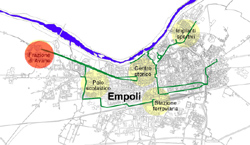
Empoli is a municipality of 44,000, half hour west of the city
of Florence, located in the region of Tuscany. The focus of
this case study is Avane, a historic community on the edge of
Empoli, close to one of the region's most important watercourses,
the Arno River. Avane is located in a historic district containing
three important structures of high cultural and historic value:
a church, a colonial house, and a neighbourhood centre. Adjacent
to this is an area intended for social housing.The plan initially
proposed for this area included insensitive architecture and
very little public open space. In order to preserve the unique
historical and cultural context of the existing urban fabric,
while also integrating it with the proposed development, an
alternative vision was needed. Local Agenda 21 provided the
context for initiating such an alternative vision. |
 |
The Headwaters
Project began with the 1995 Surrey Design Charrette, in which
the James Taylor Chair brought together a group of North American
architects and landscape architects to illustrate what the South
Newton area of Surrey might look like if designed and built
to local and regional policy prescriptions for sustainable development
(see Surrey Project). The
results of this event led to the development of seven
principles of sustainable communities, which would form
the basis of the Headwaters Project. Following the Surrey Design
Charrette, the James Taylor Chair undertook research to demonstrate
the costs and benefits of alternative
development standards, with a specific focus on green infrastructure.
Based on the progress of these projects, in December 1998, the
City of Surrey Planning and Development Department entered into
a partnership with the James Taylor Chair, Pacific Resources,
and a multi-constituent advisory committee (involving various
levels of government) in order to produce a model capable of
applying sustainable principles and alternative development
standards "on the ground." Out of this agreement grew the concept
for the Headwaters Project,
the first and most important component of which is the East
Clayton NCP.
Why East Clayton?
Surrey is geographically the largest and fastest growing municipality
in the Lower Mainland region of British Columbia. Several specific
site constraints contributed to the selection of East Clayton
for this design and planning process. Of these constraints,
drainage issues, both on the site and within receiving lowlands,
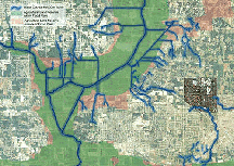
were most significant. Situated upland of the Serpentine River
agricultural flood plane, East Clayton drains into three of
the region's most significant water bodies: the Serpentine,
the Nicomekle, and the Fraser Rivers. Since the 250-hecatre
East Clayton site was at the headwaters of the stream system,
mistakes made in handling storm water here would reverberate
throughout the whole length of receiving streams and even into
the agricultural lands in the floodplains below. The City recognized
that applying conventional status quo planning and engineering
standards within this area would negatively affect these natural
watercourses. To develop East Clayton as a new "urban" neighbourhood,
a more sustainable approach was necessary. To achieve this more
sustainable design the City collaborated with the James Taylor
Chair to design the East Clayton community in a creative and
integrated way. |
![]()
